The 30 Best Hiking Trails in Colorado: Spectacular Mountain Adventures
Colorado offers some of the most diverse and spectacular hiking opportunities in the United States, featuring trails that wind through alpine lakes, towering peaks, red rock formations, and pristine wilderness areas.
The state’s varied terrain spans from the high-altitude Rocky Mountains to unique geological formations, providing hiking experiences for every skill level and interest.
This comprehensive guide features 30 carefully selected trails that showcase Colorado’s natural beauty, from accessible day hikes perfect for families to challenging summit attempts for experienced mountaineers.
Each trail offers unique rewards, whether it’s panoramic mountain views, cascading waterfalls, or encounters with diverse wildlife across different ecosystems.
Here are the 30 best hiking trails in Colorado:
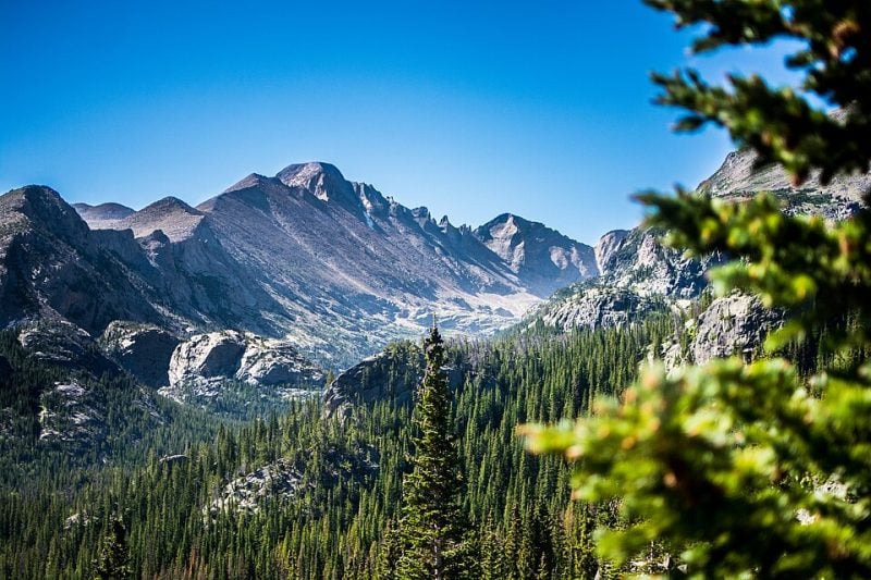
1. Emerald Lake Trail, Rocky Mountain National Park
The Emerald Lake Trail ranks among Colorado’s most accessible alpine adventures. This 3.6-mile round-trip hike gains 650 feet of elevation while visiting three pristine mountain lakes.
Hikers encounter Nymph Lake first, followed by Dream Lake, before reaching the trail’s namesake destination. Emerald Lake sits beneath towering 12,000-foot peaks along the Continental Divide.
The trail winds through pine forests where Colorado’s state flower, columbine, blooms during summer months. Flattop Mountain and Hallett Peak create dramatic reflections in the clear lake waters.
Rocky Mountain National Park’s Bear Lake serves as the trailhead for this popular route. The trail’s moderate difficulty makes it suitable for most fitness levels.
Early morning starts help hikers avoid crowds on this heavily trafficked path. The combination of three distinct lakes and mountain scenery delivers exceptional photographic opportunities throughout the journey.
2. Maroon Bells Scenic Loop, Aspen
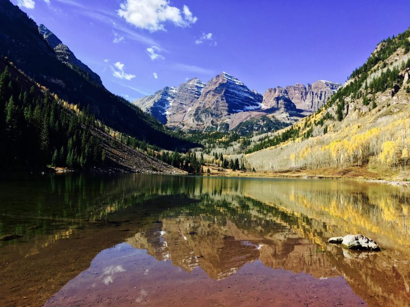
The Maroon Bells Scenic Loop Trail offers one of Colorado’s most accessible mountain experiences. This 1.5-mile roundtrip trail circles Maroon Lake with minimal elevation gain.
The trail provides clear views of the iconic Maroon Bells peaks, two 14,000-foot summits that rank among North America’s most photographed mountains. The path follows a well-maintained dirt trail through aspen groves and alpine meadows.
Families find this trail particularly suitable due to its short distance and gentle terrain. The clearly marked route takes most hikers 20-30 minutes to complete at a leisurely pace.
Located just 10 miles west of Aspen, the trailhead sits within the Maroon Bells-Snowmass Wilderness. The area attracts over 300,000 visitors annually and requires advance permits during peak season.
The trail connects easily with other area hikes for those seeking longer adventures.
3. Hanging Lake Trail, Glenwood Springs
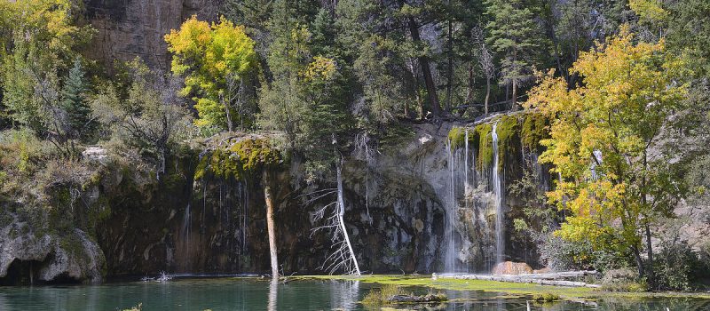
The Hanging Lake Trail offers a challenging 3.0-mile out-and-back hike near Glenwood Springs. This steep route typically takes around 2 hours to complete.
Hikers must obtain advance reservations and permits to access this popular trail. The trail begins from a designated parking area or via the paved bike path from Glenwood Springs.
The route follows the Colorado River through Glenwood Canyon before entering Dead Horse Creek Canyon. The destination features a stunning travertine lake with crystal-clear turquoise waters.
The trail leads to two waterfalls, including one that hikers can walk behind. July through October provides the best hiking conditions.
Dogs are not permitted on this trail. Visitors should expect to encounter other hikers due to the trail’s popularity among Colorado outdoor enthusiasts.
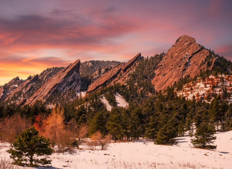
4. Chautauqua Trail, Boulder
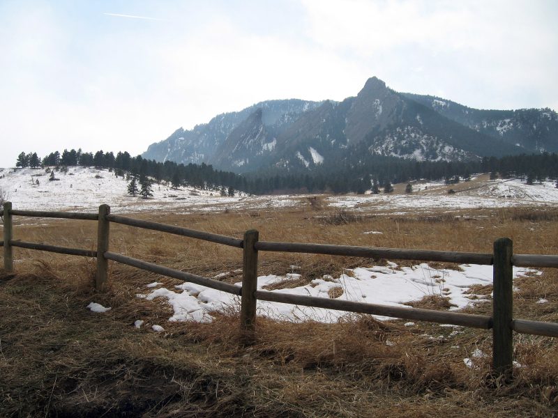
The Chautauqua Trail offers hikers a 1.3-mile out-and-back route at the base of Boulder’s iconic Flatirons. This moderately challenging trail takes approximately 49 minutes to complete.
Located in Chautauqua Park, the trail provides direct access to spectacular views of the towering sandstone formations. Hikers travel through the historic Chautauqua Meadow while gaining elevation toward the dramatic rock faces.
The wide, smooth path makes navigation straightforward for most skill levels. As hikers ascend, they can enjoy panoramic views of Boulder spreading out to the east.
This popular trail attracts both tourists and locals year-round. The best hiking conditions occur from March through November. Dogs are permitted but must remain on leash.
The trailhead serves as a gateway to 40 miles of additional hiking opportunities throughout the Flatirons area.
5. Mount Elbert Trail, Leadville
Mount Elbert stands as Colorado’s highest peak at 14,439 feet above sea level. The mountain ranks as the second highest summit in the lower 48 states.
The North Mount Elbert Trail serves as the standard route to the summit. This trailhead sits just outside Leadville and provides the most direct access to the peak.
Hikers can choose between multiple distances depending on their starting point. The trail measures approximately 11.5 miles roundtrip from the 4WD road parking area.
Despite its impressive elevation, Mount Elbert is considered one of the more accessible fourteeners in Colorado. The Northeast Ridge route follows a well-established path through the San Isabel National Forest.
Hikers should prepare for altitude effects and plan to start early in the day. Afternoon thunderstorms pose a significant risk at high elevation during summer months.
6. Bear Lake Trail, Rocky Mountain National Park
The Bear Lake Trail offers one of Colorado’s most accessible alpine hiking experiences. Located at 9,475 feet elevation, this easy loop trail spans just 0.7 miles and takes approximately 15 minutes to complete.
Hikers reach the trailhead via Bear Lake Road, a 9-mile paved route from Highway 36. The park recommends using the free shuttle system during peak season due to heavy visitation.
The nature trail provides stunning views of Continental Divide peaks reflected in pristine alpine waters. Dense forests surround the lake, creating excellent wildlife viewing opportunities.
Rocky Mountain National Park suggests hiking counter-clockwise around the lake. The trail remains open year-round and attracts visitors for birding, hiking, and running.
Bear Lake serves as a popular starting point for numerous other alpine lake hikes. Dogs are not permitted on this trail, maintaining the natural environment for wildlife.
7. Ice Lakes Basin Trail, Silverton
The Ice Lakes Basin Trail delivers some of Colorado’s most striking alpine scenery. This challenging hike climbs nearly 3,000 feet over 3.75 miles to reach brilliant turquoise lakes.
The trail begins at South Mineral Campground in San Juan National Forest. Hikers access the trailhead by driving north from Silverton on Highway 550 to County Road 7.
The route passes through aspen groves and conifer forests before reaching treeline. Two distinct basins await above the trees, surrounded by 13,000-foot peaks including Vermillion Peak and Golden Horn.
Wildflowers bloom from late July through August. The trail splits about 2 miles in, offering camping opportunities in the lower basin.
This popular trail attracts thousands of hikers each season. The steady uphill climb rewards visitors with electric blue alpine lakes and panoramic mountain views.
8. Pawnee Buttes Loop, Pawnee National Grassland
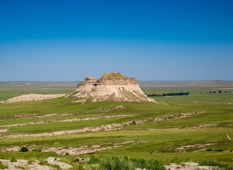
The Pawnee Buttes Trail offers hikers a distinctive grassland experience in northeastern Colorado. Located in Weld County near the Wyoming border, these prominent sandstone formations rise 300 feet above the surrounding prairie.
This moderate trail spans approximately 4.3 miles round trip with minimal elevation gain of 328 feet. The path leads hikers across open grassland to reach the first butte, providing expansive views of Colorado’s high plains.
Birding enthusiasts frequently visit this location, as over 300 species have been documented in the area. Mountain plovers, lark buntings, and various raptors inhabit the grassland ecosystem.
The trailhead sits about 35 miles east of Fort Collins, accessible via several miles of dirt roads. Hikers should prepare for exposed conditions with limited shade throughout the journey.
9. Garden of the Gods Loop, Colorado Springs
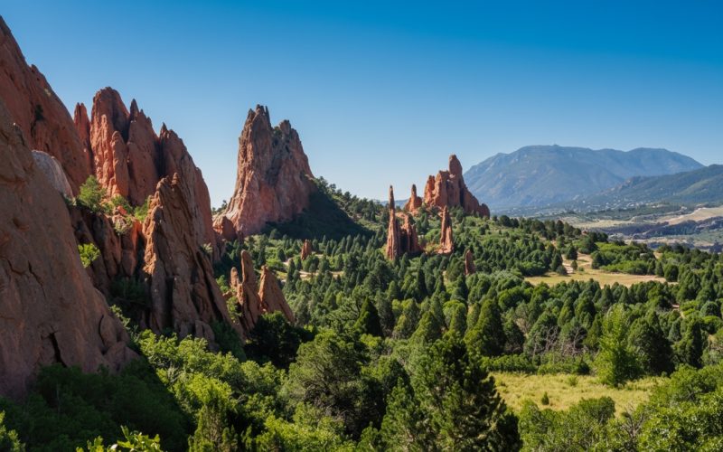
The Garden of the Gods Loop offers hikers spectacular views of towering red sandstone formations in Colorado Springs. This public park attracts outdoor enthusiasts from around the world.
The loop trail provides access to multiple hiking options within the park. Visitors can choose from easy walks to more challenging routes depending on their fitness level.
The Perkins Central Garden Trail spans 1.5 miles roundtrip with minimal elevation gain. This paved path takes hikers through the heart of the park beneath the tallest rock formations.
The Ridge Trail offers a moderate half-mile loop with under 100 feet of elevation change. This trail provides elevated views of the sandstone spires and surrounding landscape.
Rock climbing and bouldering opportunities abound throughout the area. Mountain biking trails also wind through the park for cyclists seeking adventure.
The park features over 30 different trails according to hiking resources. Each trail offers unique perspectives of the geological formations and Front Range mountains.
10. Flatirons Trail, Boulder
The Flatirons Trail offers hikers access to Boulder’s most recognizable rock formations. These striking sandstone slabs rise dramatically from the foothills west of the city.
The trail to the First and Second Flatirons covers approximately 2.6 miles round trip. Hikers cross open meadows before ascending through a natural notch between the towering rock faces.
The route begins near Chautauqua Park, a popular trailhead with parking and facilities. The trail gains about 1,400 feet in elevation over moderate terrain.
Views from the trail showcase the Front Range and the Denver metropolitan area to the east. The sandstone formations create a natural amphitheater setting.
The Flatirons consist of five numbered formations along Green Mountain’s eastern slope. These tilted rock slabs formed from ancient sedimentary deposits and weathering processes.
Trail conditions vary seasonally, with spring and fall offering ideal hiking weather. Early morning starts help avoid crowds on this popular Boulder destination.
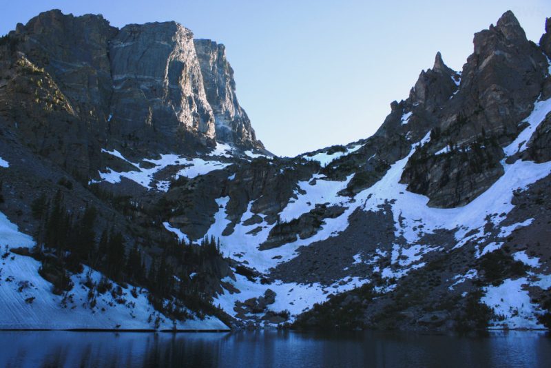
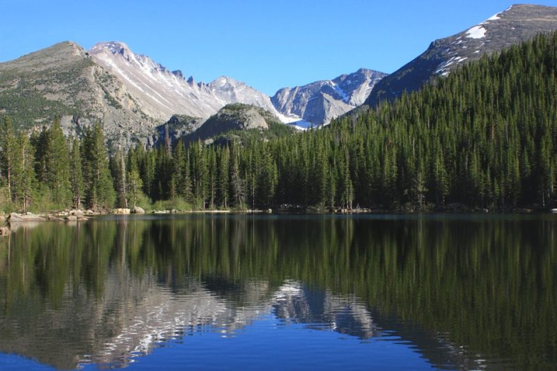
11. Sky Pond via Glacier Gorge Trail, RMNP
Sky Pond stands as one of Rocky Mountain National Park’s most stunning alpine destinations. The trail begins at Glacier Gorge Trailhead and stretches approximately 9 miles roundtrip.
Hikers traverse past multiple waterfalls and pristine mountain lakes. The route leads through Loch Vale and Lake of Glass before reaching Sky Pond.
The demanding trail gains significant elevation through rocky terrain. Adventurers encounter cascading streams and sweeping mountain vistas throughout the journey.
Sky Pond sits nestled beneath towering granite walls. The crystal-clear alpine lake rewards hikers with breathtaking scenery.
Camping opportunities exist along the trail for those seeking overnight adventures. The trailhead requires access via Bear Lake Road from the park entrance.
This hike ranks among the most challenging yet rewarding experiences in Rocky Mountain National Park.
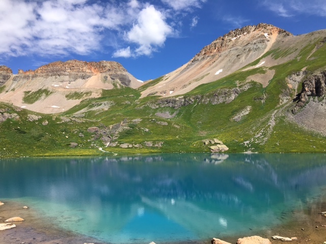
12. Blue Lakes Trail, American Basin
The Blue Lakes Trail winds through the Mount Sneffels Wilderness in Colorado’s San Juan Mountains. This moderate hike leads to a series of stunning alpine lakes with crystal-clear turquoise water.
The trail begins with a steady climb through pine forests and wildflower meadows. Hikers enjoy partial mountain views during the first hour of the ascent.
After approximately 90 minutes of hiking, the terrain opens up significantly. A beautiful waterfall appears on the left side just before reaching the first lake.
The trail connects three distinct lakes at different elevations. Each lake offers unique views surrounded by impressive mountain peaks in the wilderness area.
Hikers can access the trailhead from nearby towns including Ridgway, Ouray, and Telluride. The location between these popular Colorado destinations makes it convenient for day trips.
The trail provides excellent value with its combination of alpine scenery and moderate difficulty level.
13. Mount Bierstadt Trail, Georgetown
Mount Bierstadt stands at 14,065 feet and ranks among Colorado’s most accessible fourteeners. The trail sits approximately 40 miles west of Denver in the Mount Evans Wilderness.
This 7.2-mile out-and-back hike gains 2,736 feet of elevation. Most hikers complete the journey in 6-8 hours. The trailhead is located at Guanella Pass Road near Georgetown.
The route is classified as Class 2 and considered moderately difficult. It attracts both beginners and experienced hikers due to its manageable challenge level.
Hikers start on relatively flat terrain before entering the Mount Blue Sky Wilderness. After crossing Scott Gomer Creek, the trail begins its steady climb toward the summit.
Clear days offer excellent views, including glimpses of the Denver skyline. The trail becomes crowded on summer weekends due to its popularity and proximity to the Front Range.
14. James Peak Trail, Golden
James Peak stands at 13,272 feet and ranks among Colorado’s most popular thirteeners. The trail offers multiple route options, all classified as Class 2 difficulty with some Class 2+ sections on the descent.
Hikers can access the peak via Saint Mary’s Glacier, creating an 8.2-mile round trip adventure. The route requires high clearance 4WD vehicles to reach the trailhead near Central City.
The trail features loose gravel and rocky terrain that challenges ankles in both directions. Beyond the lake and past the glacier section, the path becomes particularly demanding with unstable footing.
Summer conditions are ideal for this hike. Recent reports indicate spikes are not necessary, and hikers can navigate around the glacier safely using established trails.
The east face climb provides classic Colorado high-altitude hiking without technical requirements. Views from the summit and throughout the ascent reward hikers for their effort on this Front Range favorite.
15. Devil’s Head Trail, Rampart Range
Devil’s Head Trail leads to Colorado’s only remaining staffed fire lookout tower in the Front Range. The 2.8-mile out-and-back hike sits within Pike National Forest, about an hour southwest of Denver.
The trail begins at Devil’s Head Campground along Rampart Range Road. Hikers gain 864 feet of elevation to reach the 9,748-foot summit.
The granite outcropping provides 360-degree panoramic views of the surrounding wilderness. A historic fire tower crowns the peak, operational since 1912 and listed on the National Register of Historic Places.
Visitors climb 143 steps to reach the lookout platform. The moderate trail offers excellent family-friendly hiking through shaded forest terrain.
Access requires driving on dirt roads that remain passable for most passenger vehicles. Winter road closures typically add an extra mile of hiking to reach the trailhead.
16. Lost Lake Trail, Vail
Lost Lake Trail stands out as one of Vail’s most accessible hiking options. This 7-mile out-and-back trail requires approximately 3 hours to complete.
The route maintains moderate difficulty with elevation gain under 1,000 feet. Hikers can access the trail from two trailheads on Forest Service Roads #786 and #700.
The trail features classic Colorado mountain scenery including alpine lakes and aspen groves. During fall months, golden aspens create particularly striking displays along the path.
Lost Lake serves as a popular destination for both hiking and mountain biking. The singletrack trail accommodates multi-directional use throughout the warmer months.
Winter transforms this trail into a snowshoeing destination. The distance from parking areas means fewer crowds during cold weather months, making it suitable for experienced winter hikers.
17. Snowmass Lake Trail, Snowmass Village
The Snowmass Lake Trail leads hikers to one of Colorado’s most stunning high-elevation alpine lakes. This challenging backcountry route rewards adventurers with breathtaking mountain scenery and pristine wilderness.
The trail climbs steadily through diverse terrain before reaching the spectacular lake basin. Hikers encounter aspen groves, wildflower meadows, and rocky alpine landscapes along the way.
Snowmass Lake sits dramatically beneath towering cliffs and ridgelines. The crystal-clear waters reflect Snowmass Mountain and surrounding peaks, creating picture-perfect views.
The lake features designated camping areas for backpackers seeking multi-day adventures. Anglers find excellent fishing opportunities in the pristine waters.
Wildlife sightings are common throughout the area. The trail provides access to additional backcountry routes for experienced hikers.
This demanding hike requires proper preparation and mountain experience. Weather conditions can change rapidly at high elevation, making appropriate gear essential for safety.
18. Longs Peak Keyhole Route, RMNP
The Keyhole Route offers the only non-technical path to Longs Peak’s 14,259-foot summit. This challenging trail spans 14.5 miles roundtrip with over 5,000 feet of elevation gain.
Hikers begin at the Longs Peak Trailhead, located one mile past the ranger station off Highway 7. The parking lot fills early on weekends due to limited space.
The route traverses diverse terrain from forest trails to alpine tundra. After reaching the distinctive Keyhole formation, exposed rock scrambling begins on the upper sections.
This trail requires hand-and-foot climbing on granite faces above treeline. Weather conditions change rapidly at high elevation, making early starts essential for safety.
Longs Peak stands as Rocky Mountain National Park’s highest summit and Colorado’s northernmost fourteener. The demanding route rewards experienced hikers with panoramic Rocky Mountain views.
19. Fish Creek Falls Trail, Steamboat Springs
Fish Creek Falls Trail offers hikers a spectacular 280-foot waterfall just minutes from downtown Steamboat Springs. The trailhead sits approximately three miles from town along Fish Creek Falls Road.
Two viewing options make this trail accessible to various skill levels. The overlook trail provides wheelchair and stroller-friendly access to views of Lower Fish Creek Falls.
A second trail descends to the waterfall’s base, offering closer views but requiring more effort. The lower sections become rockier and more challenging as hikers approach the falls.
The trail functions as a year-round destination in Routt National Forest. Summer visitors enjoy hiking and biking opportunities, while winter transforms the path into a popular snowshoeing route.
Fish Creek originates from small lakes in the Rabbit Ears Range. The trail continues beyond the falls to connect with Wyoming Trail and Mountain View Trail for extended hiking options.
20. Bridal Veil Falls Trail, Telluride
Bridal Veil Falls stands as Colorado’s tallest free-falling waterfall at 365 feet. The trail leads hikers through stunning alpine scenery to reach this impressive natural landmark.
A newer dedicated trail now provides access to the waterfall’s base without using the old jeep road. This scenic route offers a more enjoyable hiking experience through the terrain.
The trail features rocky sections that require proper hiking boots. Creek crossings may occur depending on water levels, so extra socks can be helpful for keeping feet dry.
Hikers can choose to visit just the waterfall’s base or continue upward to the top. The upper section provides views of a historic power plant and overlooks of the Telluride valley below.
The trail connects to other routes for those seeking longer adventures. Multiple trail options allow hikers to customize their experience based on desired difficulty and distance.
21. Medano Pass Primitive Road, Great Sand Dunes
Medano Pass Primitive Road offers a unique 22-mile backcountry driving experience through Great Sand Dunes National Park and Preserve. This challenging route requires a high-clearance 4WD vehicle and connects Colorado Highway 69 with the park’s main entrance.
The trail climbs to 10,040 feet at Medano Pass, crossing the Sangre de Cristo Mountains. Drivers encounter nine creek crossings, deep sand sections, and rocky terrain that becomes increasingly technical near the summit.
The road follows the historic 1806 route of Lieutenant Zebulon Pike’s expedition. It provides access to primitive camping areas and stunning views of North America’s tallest sand dunes.
This seasonal road operates only during warmer months due to snow and creek conditions. The challenging terrain includes rock gardens, water crossings, and sandy stretches that test vehicle capabilities and driver skills.
22. Greys and Torreys Peaks Trail, Silver Plume
The Greys and Torreys Peaks Trail offers access to two of Colorado’s premier fourteeners from the Stevens Gulch trailhead near Silver Plume. Greys Peak reaches 14,270 feet while Torreys Peak stands at 14,267 feet.
The trail follows an obvious route through Stevens Gulch with clear markings throughout the ascent. Hikers encounter wildflower displays during summer months and may spot mountain goats along the way.
Most hikers tackle both peaks in a single day using a clockwise route. The trail reaches the Torreys Peak junction at 13,270 feet after 2.8 miles. From there, hikers can continue left to Greys Peak or head right toward the saddle.
Summer brings heavy crowds to this popular route. Early morning starts help avoid both traffic and afternoon thunderstorms that frequently develop above treeline.
23. Mt. Quandary Trail, Breckenridge
Mt. Quandary stands as Colorado’s most climbed fourteener. The trail sits just 20 minutes from downtown Breckenridge and requires no high-clearance vehicle.
The 7.5-mile round trip covers significant elevation gain of approximately 900 feet per mile. Hikers start through wooded terrain before emerging above treeline after one mile.
The exposed east ridge leads to the 14,265-foot summit. Rocky switchbacks characterize the upper sections of the trail.
Parking reservations or shuttle rides are mandatory from mid-June through mid-September. The trail remains accessible to most hikers from June to September when snow clears.
Mountain goats frequently appear along the route. The trailhead sits 8 miles south of Breckenridge on Colorado Highway 9, then west on Blue Lakes Road to McCullough Gulch Road.
24. Bear Tooth Trail, Flat Tops Wilderness
The Bear Tooth Trail winds through Colorado’s Flat Tops Wilderness, one of the state’s three largest wilderness areas. This remote trail offers hikers access to rugged Rocky Mountain terrain at elevations reaching over 10,000 feet.
Located in the 235,214-acre wilderness area, the trail provides opportunities for both day hiking and backpacking adventures. The path traverses diverse landscapes typical of the Flat Tops region.
Hikers encounter fewer crowds compared to Colorado’s more popular wilderness destinations. The trail connects with other routes in the area, including the Bear River Trail junction system.
Anglers often use this trail to reach backcountry lakes, though fishing requires proper permits from the Colorado Division of Wildlife. The wilderness boundary is clearly marked along the route.
The trail serves as a gateway to explore the Flat Tops’ unique geological formations and alpine ecosystems.
25. Crystal Mill Hike, Marble
The Crystal Mill hike leads to one of Colorado’s most photographed landmarks. This 1892 wooden powerhouse sits on an outcrop above the Crystal River near Marble.
The trail follows County Road 3 for approximately 4.5 miles each way. Hikers gain elevation along the rugged mountain road that runs parallel to the Crystal River through the White River National Forest.
The structure served as a compressor station rather than a traditional watermill. It used water turbines to drive air compressors for mining operations in the historic town of Crystal.
Visitors can access the mill by four-wheel drive or on foot. The hiking route passes colorful Lizard Lake and offers pristine mountain views throughout the journey.
No camping is permitted in the area. Hikers should prepare for a long day with proper supplies and expect challenging terrain on this backcountry trail.
26. Cathedral Lake Trail, RMNP
Cathedral Lake Trail offers hikers access to one of Colorado’s most scenic alpine destinations. The trail spans 5.4 miles round trip with over 2,000 feet of elevation gain.
Located near Aspen in the Maroon Bells Snowmass Wilderness Area, this challenging hike follows Pine Creek canyon. The route climbs steeply through forests and meadows before reaching the alpine basin.
The trail features difficult terrain with rocky sections and switchbacks that earn it a difficult rating from the Forest Service. Hikers can expect stunning views of the Elk Mountain Range throughout the journey.
Cathedral Lake sits nestled in a dramatic cirque beneath granite peaks. The alpine lake provides a rewarding destination surrounded by towering mountains.
Fall visitors can witness golden aspen displays, though the trail becomes crowded during peak foliage season. The area also offers excellent wildflower viewing opportunities during summer months.
27. Golden Gate Canyon State Park Trails, Golden
Golden Gate Canyon State Park sits just 30 miles northwest of Denver in the Front Range. The park spans 12,000 acres of diverse Colorado terrain.
Hikers can explore over 35 miles of marked trails throughout the park. The twelve main trails each carry animal names with corresponding two-letter abbreviations for easy identification.
Trail options range from gentle walks through mountain meadows to challenging climbs toward rocky peaks. Visitors encounter streams, forests, and open grasslands along the various routes.
The park operates year-round with seasonal activities. Winter brings opportunities for cross-country skiing and snowshoeing on many of the same trail systems.
Panorama Point Scenic Overlook provides expansive views of Colorado’s Continental Divide. The park offers both day hiking and overnight camping options for extended adventures.
28. Mount Zirkel Wilderness Loop, Oak Creek
The Mount Zirkel Wilderness Loop, also known as the Zirkel Circle, combines the Gilpin Lake Trail and Gold Creek Lake Trail into an 11-mile scenic loop. This trail provides access to over 159,935 acres of protected wilderness in northwestern Colorado.
The loop begins at the Slavonia Trailhead near Clark, Colorado, approximately 30 minutes north of Steamboat Springs. Hikers traverse through pristine mountain terrain within one of the original wilderness areas designated in 1964.
The trail features two alpine lakes and passes through diverse terrain including aspen groves that create spectacular fall colors. Multiple camping options exist along the route for backpackers following wilderness regulations.
The Mica Basin Trail offers a notable spur option leading to Mica Lake at the base of the Agnes peaks. This wilderness area contains the headwaters of major rivers and approximately 70 lakes throughout the region.
29. Crested Butte to Gothic Trail, Crested Butte
The Crested Butte to Gothic Trail follows the scenic Washington Gulch route through one of Colorado’s most picturesque mountain corridors. This popular trail begins at approximately 9,600 feet elevation and extends about 10 miles from Crested Butte to the historic Gothic townsite.
Hikers travel along Trail 403, which winds through dense forest before opening to expansive mountain vistas. The trail offers stunning wildflower displays during peak season, typically from mid-July through August.
Four-wheel or all-wheel drive vehicles are recommended to reach the trailhead. The route provides access to Gothic Mountain climbing opportunities for those seeking additional challenges.
The trail serves as both a destination hike and gateway to the East River Valley’s alpine terrain. Visitors can explore the remnants of Gothic, a former mining town established in the 1870s.
This moderate trail attracts hikers, mountain bikers, and nature photographers throughout the summer months.
30. Hermit Falls Trail, Glenwood Springs
Hermit Falls Trail offers hikers a moderate adventure through Colorado’s scenic landscape near Glenwood Springs. The trail leads to a beautiful waterfall tucked away in the mountains.
This hiking route provides excellent views of the surrounding Roaring Fork Valley. Hikers can expect varied terrain as they make their way toward the falls.
The trail spans approximately 3 miles roundtrip with moderate elevation gain. Most hikers complete the journey in 2-3 hours depending on pace and stops.
Spring and early summer provide the best conditions for viewing the falls at full flow. The trail remains accessible during most of the hiking season.
Visitors should bring plenty of water and wear sturdy hiking boots for the rocky sections. The trail can be slippery near the waterfall area.
Planning Your Colorado Hiking Adventure
Successful Colorado hiking requires proper preparation for high-altitude conditions, seasonal weather patterns, and terrain challenges. Essential gear, timing, and trail difficulty assessment form the foundation of safe mountain adventures.
Essential Gear for High-Altitude Trails
Sun Protection becomes critical above 8,000 feet where UV exposure increases significantly. Hikers need sunscreen with SPF 30 or higher, sunglasses, and wide-brimmed hats.
- Layer System handles Colorado’s rapid weather changes effectively:
- Base layer: moisture-wicking synthetic or merino wool
- Insulating layer: fleece or down jacket
- Shell layer: waterproof and windproof outer jacket
Hydration and Nutrition requirements increase at altitude. Carry 3-4 liters of water for full-day hikes and electrolyte supplements to prevent altitude-related dehydration.
Emergency Essentials include a first aid kit, headlamp with extra batteries, emergency whistle, and space blanket. Cell service remains unreliable in many mountain areas.
Footwear should provide ankle support and traction on rocky terrain. Hiking boots with sturdy soles prevent injuries on Colorado’s loose scree and steep switchbacks.
Best Seasons for Hiking in Colorado
Summer (June-September) offers the most accessible conditions for high-altitude trails. Most mountain passes open by mid-June, though snow persists on north-facing slopes through July.
Spring (April-May) provides excellent hiking at lower elevations below 9,000 feet. Trails around Boulder, Colorado Springs, and the Front Range remain snow-free while offering comfortable temperatures.
Fall (September-October) delivers ideal conditions with cool temperatures and fewer crowds. Aspen trees change colors in late September, creating spectacular scenery on many trails.
Winter (November-March) limits hiking to lower elevation trails and requires snowshoes or microspikes. Many high-country roads close, making popular summer destinations inaccessible.
Afternoon Thunderstorms occur regularly from July through September, typically developing between 1 PM and 4 PM. Start early and plan to descend from exposed ridges by noon.
Understanding Trail Difficulty Ratings
Easy Trails feature less than 500 feet of elevation gain over distances under 3 miles. These routes suit families and beginners building fitness for more challenging adventures.
Moderate Trails involve 500-1,500 feet of elevation gain over 3-6 miles. Hikers should possess basic fitness levels and comfortable hiking experience on uneven terrain.
Difficult Trails demand 1,500+ feet of elevation gain, often exceeding 8-10 miles total distance. These routes require advanced fitness, navigation skills, and experience with exposure.
Class 3 and 4 Routes involve scrambling with hands and feet on rock faces. These technical routes demand mountaineering experience and specialized equipment beyond standard hiking gear.
Elevation Considerations significantly impact difficulty ratings. Trails above 10,000 feet affect oxygen availability, requiring slower paces and frequent rest stops regardless of distance or grade.
Tips for Responsible and Safe Hiking
Colorado’s high-altitude environment and diverse ecosystems require hikers to follow specific safety protocols and conservation practices. Proper preparation for wildlife encounters, rapidly changing mountain weather, and adherence to environmental protection standards ensures both hiker safety and trail preservation.
Leave No Trace Principles
Pack it in, pack it out applies to all trash, food scraps, and personal items. Even organic waste like banana peels and apple cores should be carried out, as they can take months to decompose in Colorado’s dry climate.
Stay on designated trails to prevent erosion and protect fragile alpine vegetation. Colorado’s high-altitude plants grow slowly and can take decades to recover from trampling damage.
Camp only in established sites or at least 200 feet from water sources and trails. Many Colorado wilderness areas prohibit camping above treeline to protect delicate alpine ecosystems.
Dispose of human waste properly by digging catholes 6-8 inches deep and 200 feet from water sources. Pack out toilet paper in plastic bags, as it doesn’t decompose quickly in arid conditions.
Leave rocks, plants, and natural objects undisturbed. Colorado’s wildflowers and archaeological sites are protected by law.
Minimize campfire use and follow current fire restrictions. Use established fire rings below treeline only when permitted.
Wildlife Awareness and Safety
Black bears are active throughout Colorado’s hiking areas. Store food in bear-proof containers or hang it 12 feet high and 4 feet from tree trunks. Never feed bears or leave food scraps behind.
Mountain lions inhabit most Colorado hiking areas. Make noise while hiking, travel in groups, and maintain eye contact if encountered. Appear large by raising arms or jackets overhead.
Rattlesnakes are common below 8,000 feet elevation from April through October. Wear closed-toe shoes and stay on trails. They typically rattle before striking when threatened.
Elk and moose can be aggressive, especially during mating season in fall. Keep at least 25 yards distance and never approach calves.
Proper food storage includes keeping all scented items in sealed containers. This includes toiletries, sunscreen, and cooking utensils.
Weather Preparedness in the Rockies
Afternoon thunderstorms develop rapidly above treeline between 11 AM and 4 PM during summer months. Start early and descend below treeline by noon to avoid lightning strikes.
Temperature drops of 30-40 degrees can occur within hours at high elevation. Pack insulating layers even for summer day hikes.
Altitude sickness affects many hikers above 8,000 feet. Ascend gradually, stay hydrated, and recognize symptoms including headaches, nausea, and dizziness.
Flash floods can occur in slot canyons and drainage areas during thunderstorms. Check weather forecasts and avoid narrow canyons during storm warnings.
Snow conditions persist year-round above 12,000 feet. Carry microspikes or crampons for high-altitude hikes even in summer.
Essential gear includes rain jacket, warm layers, first aid kit, headlamp, and extra food and water. Weather conditions change rapidly in mountain environments.


