The 30 Best Hiking Trails in the U.S. for Every Skill Level and Adventure Type
The United States offers an extraordinary collection of hiking trails that showcase the nation’s diverse landscapes, from towering mountain peaks to dramatic desert canyons. With over 88,600 miles of established trails across the country, hikers can explore everything from coastal rainforests to alpine wilderness areas.
These 30 exceptional trails represent the pinnacle of American hiking experiences, spanning iconic destinations like national parks and lesser-known gems that deliver unforgettable adventures. Each trail offers unique challenges and rewards, whether seeking technical rock scrambles, gentle forest walks, or multi-day wilderness expeditions.
From the rugged coastlines of Maine to the volcanic landscapes of Hawaii, these carefully selected routes provide access to America’s most spectacular natural wonders and ensure hikers of all skill levels can find their perfect outdoor adventure.
Here are the 30 best hiking trails in the U.S.
1. Appalachian Trail, Eastern U.S.
The Appalachian Trail spans 2,190 miles from Springer Mountain in Georgia to Mount Katahdin in Maine. This legendary footpath crosses 14 states through the Appalachian mountain range.
The trail offers diverse landscapes including dense forests, open meadows, and rugged peaks. Hikers encounter varying ecosystems and wildlife throughout the journey.
Most people tackle the AT through section hikes rather than thru-hiking the entire trail. Popular sections include stretches through Virginia’s Blue Ridge Mountains and New Hampshire’s White Mountains.
The trail provides options for day hikes, weekend backpacking trips, and week-long adventures. Well-maintained shelters and established campsites support overnight stays.
Hikers should prepare for challenging terrain and variable weather conditions. The trail attracts thousands of visitors annually, making it one of America’s most popular long-distance hiking destinations.
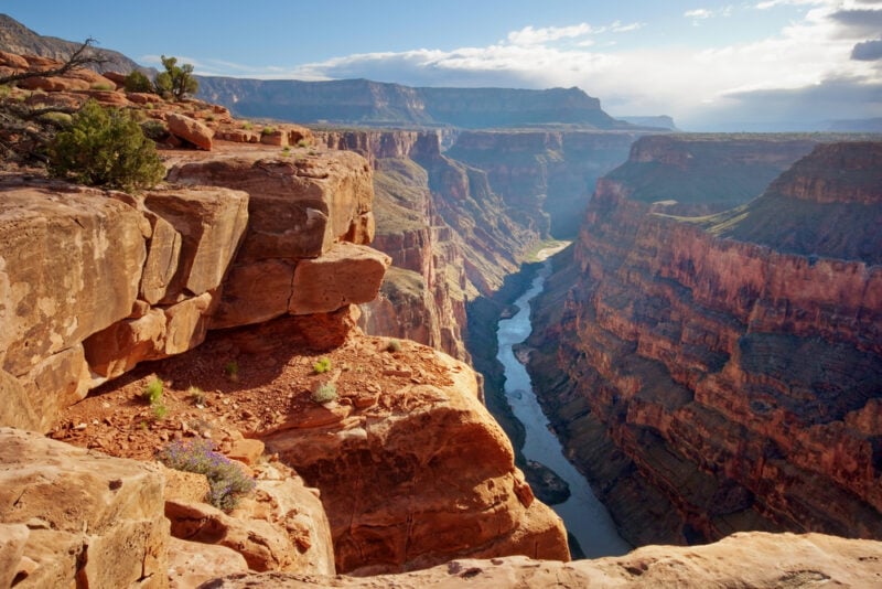
2. Grand Canyon Rim Trail, Arizona
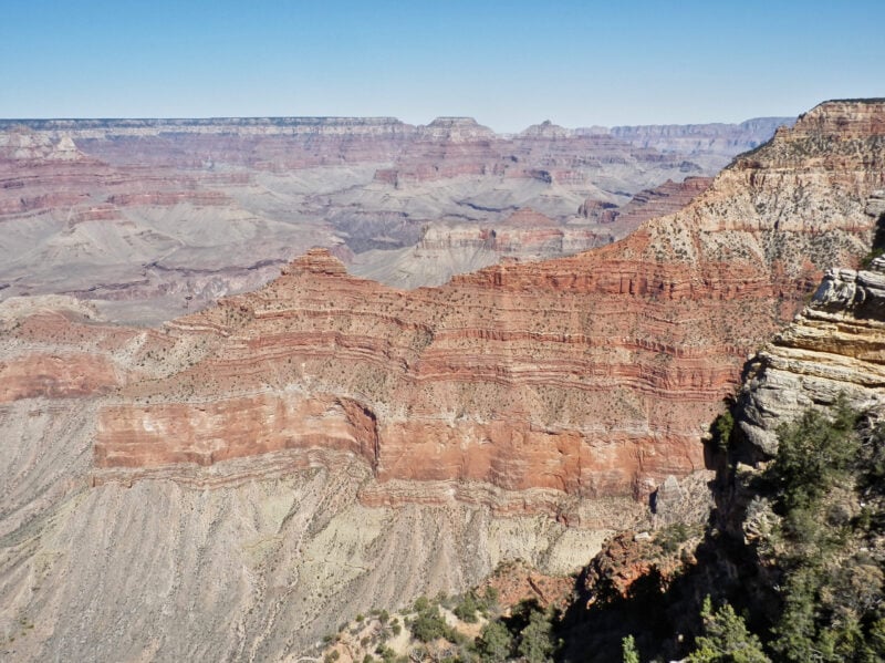
The Grand Canyon Rim Trail spans 12.7 miles along the South Rim, connecting nine scenic viewpoints. This mostly paved trail offers spectacular canyon views with minimal elevation change.
The trail takes an average of 4 hours and 29 minutes to complete as a point-to-point hike. Hikers can customize their experience by using the shuttle system that connects each viewpoint.
Most sections are paved and wheelchair accessible. The well-defined path provides excellent shade along various portions of the route.
The Trail of Time section offers educational displays about the canyon’s geological history. Hikers encounter interpretive exhibits that enhance their understanding of this natural wonder.
March through November provides optimal hiking conditions. The trail remains popular year-round, so hikers should expect to encounter other visitors.
Dogs are permitted but must remain on leash. The trail serves hikers of all skill levels seeking canyon views without strenuous elevation gains.
3. Half Dome Trail, Yosemite National Park
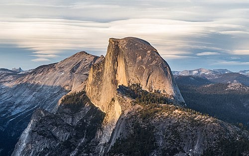
Half Dome stands as one of America’s most challenging and iconic hiking trails. The granite monolith rises 8,800 feet above sea level in California’s Sierra Nevada mountains.
This strenuous day hike requires 10-14 hours to complete the round trip. The National Park Service considers it the most demanding day hike in Yosemite.
Hikers must obtain permits through a lottery system in March or secure limited permits two days in advance. The trail passes Vernal and Nevada waterfalls while winding through sequoia forests.
The final ascent uses steel cables to reach the summit. This section demands physical fitness and mental preparation.
The trail offers panoramic views of Yosemite Valley from the top. Proper preparation and safety planning are essential for this challenging trek.
4. Zion Angels Landing, Utah
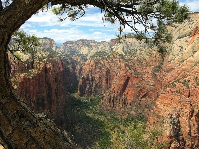
Angels Landing stands as one of America’s most challenging and rewarding day hikes. This 5-mile round-trip trail climbs 1,500 vertical feet to reach the summit at 5,790 feet elevation.
The trail begins at the Grotto trailhead in Zion National Park. Hikers navigate steep switchbacks carved into solid rock, originally constructed in 1926.
The final half-mile presents the most technical section. Chain railings bolted into the rock provide safety assistance along narrow ledges with sheer drop-offs on both sides.
Physical fitness and mental preparation are essential for this demanding hike. The steep terrain and exposed sections require careful attention and sure footing.
Summit views reward hikers with panoramic vistas of Zion Canyon stretching in both directions. The Great White Throne formation appears remarkably close from the landing.
A timed permit system now regulates access to this popular destination during peak seasons.
5. Glacier National Park Highline Trail, Montana
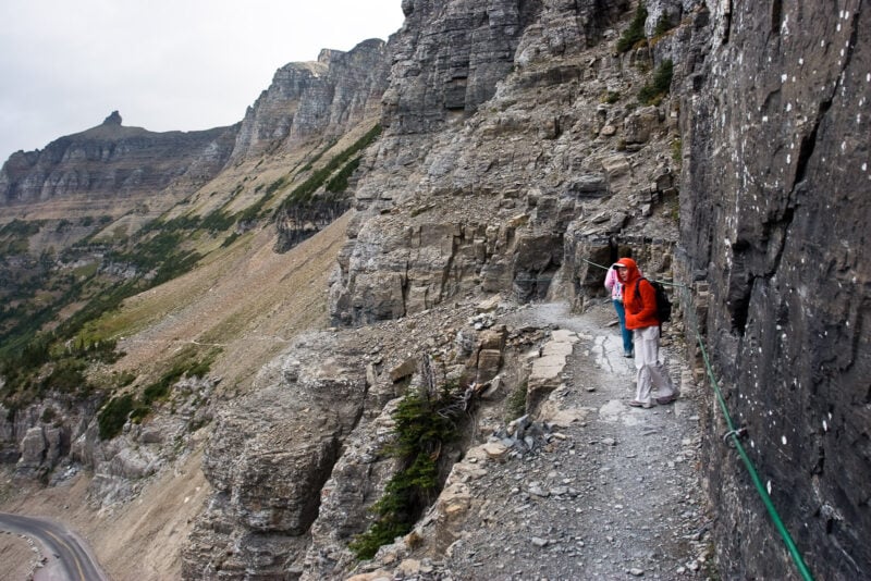
The Highline Trail ranks among Montana’s premier hiking experiences. This challenging trail stretches 7.6 miles one-way from Logan Pass Visitor Center to Granite Park Chalet.
Hikers traverse high above Going-to-the-Sun Road throughout most of the journey. The trail offers spectacular mountain vistas and opportunities to spot wildlife including mountain goats and bears.
The route remains open seasonally from July through October. Summer months provide the best conditions for hiking this alpine trail.
Most visitors choose the out-and-back option to Granite Park Chalet rather than the full through-hike. The historic chalet serves as a popular turnaround point.
Logan Pass parking fills quickly during peak season. The free shuttle system provides reliable transportation to the trailhead for those seeking to avoid parking challenges.
6. John Muir Trail, California
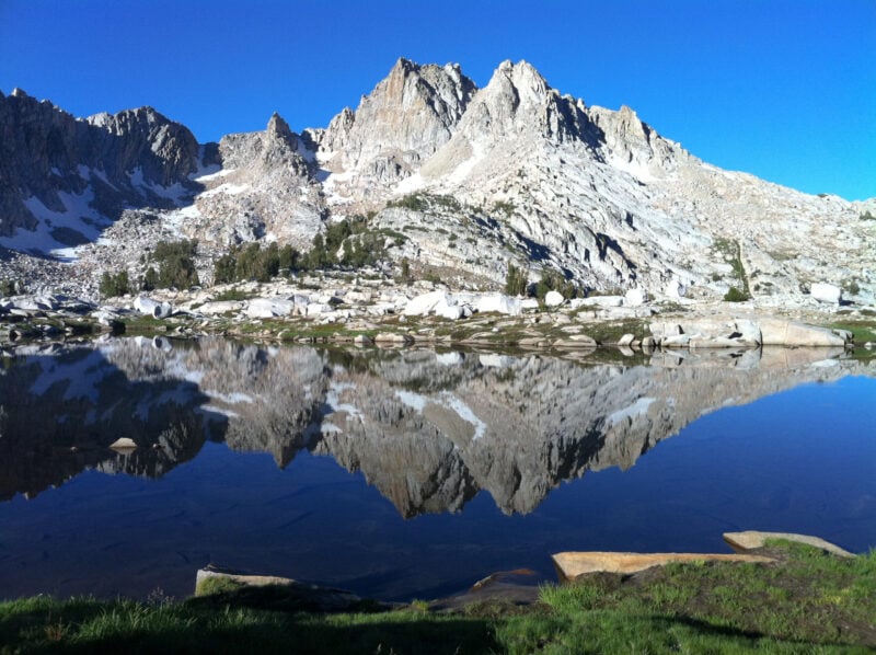
The John Muir Trail spans 211 miles through California’s Sierra Nevada Mountains. This legendary trail connects Yosemite Valley to Mount Whitney, offering hikers some of the most spectacular alpine scenery in the United States.
The trail passes through Kings Canyon National Park and Sequoia National Park. Hikers encounter pristine alpine lakes, granite peaks, and wildflower meadows throughout their journey.
Most backpackers complete the trail in 2-3 weeks. The route involves nearly 80,000 feet of elevation change, making it a challenging trek that requires proper preparation and fitness.
The trail crosses designated wilderness areas and national forests. Permits are required for overnight camping, and hikers must be self-sufficient with food and gear.
The best hiking season runs from June through October when snow has cleared from high passes. This timing allows access to the trail’s most remote sections while avoiding harsh winter conditions.
7. Pacific Crest Trail, West Coast
The Pacific Crest Trail stretches 2,650 miles from Mexico to Canada through California, Oregon, and Washington. This National Scenic Trail ranks among America’s most challenging long-distance hiking experiences.
The trail crosses 25 national forests and seven national parks. Hikers encounter desert landscapes, Sierra Nevada peaks, dense forests, and Cascade Range volcanic summits.
Most thru-hikers begin in Campo, California and finish at Manning Park, British Columbia. The journey typically takes four to six months to complete.
The PCT passes through extreme terrain variations. Sections include arid deserts, glaciated mountain passes, and remote wilderness areas with limited resupply options.
Day hikers and section hikers also use portions of the trail. The route provides access to some of the West Coast’s most pristine wilderness areas and scenic mountain ridges.
8. Grand Tetons Cascade Canyon Trail, Wyoming
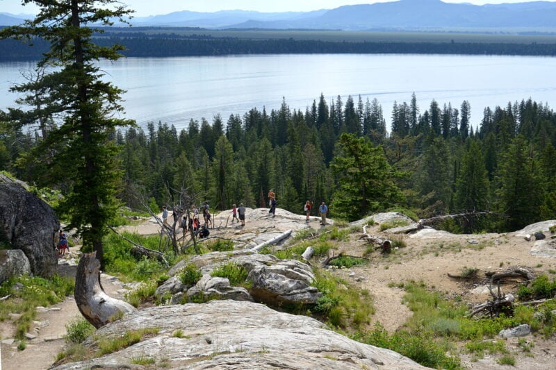
The Cascade Canyon Trail delivers one of the best effort-to-reward ratios in Grand Teton National Park. This popular hike starts from Jenny Lake’s boat dock and leads hikers through spectacular mountain scenery.
The trail first reaches Hidden Falls, a 200-foot waterfall that provides dramatic views. Continuing upward, hikers encounter multiple switchbacks leading to Inspiration Point.
Inspiration Point offers outstanding views of Jenny Lake and the surrounding Teton Mountains. Beyond this viewpoint, the trail becomes more gradual as it winds through deep woods toward the canyon’s interior.
The full hike to Lake Solitude covers 13.9 miles out-and-back and typically takes about 6 hours 27 minutes to complete. This challenging route attracts backpackers, birders, and day hikers.
The best hiking season runs from May through October when weather conditions are most favorable.
9. Bryce Canyon Navajo Loop, Utah
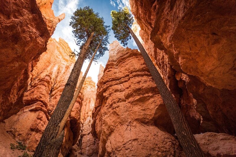
The Navajo Loop Trail stands as Bryce Canyon National Park’s most popular hiking destination. This 1.5-mile loop trail offers hikers direct access to the canyon’s famous hoodoos and rock formations.
The trail begins at Sunset Point and descends into the amphitheater through switchbacks. Hikers pass through Wall Street, a narrow slot canyon section flanked by towering Douglas fir trees and steep cliff walls.
The moderate difficulty level makes this trail accessible to most hikers. The route takes approximately one hour to complete, though the elevation gain can be challenging for some visitors.
Key landmarks include Thor’s Hammer and the dramatic hoodoo formations throughout the canyon floor. The trail provides close-up views of the unique geological features that make Bryce Canyon distinctive.
April through October offers the best hiking conditions. Dogs are not permitted on this trail.
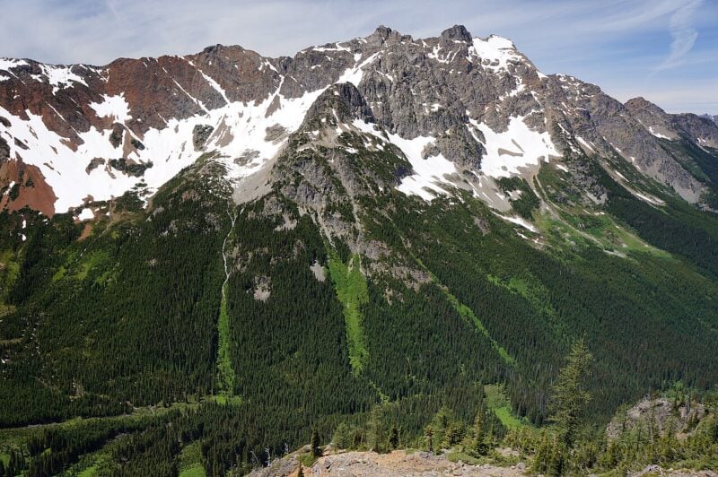
10. Mount Rainier Wonderland Trail, Washington
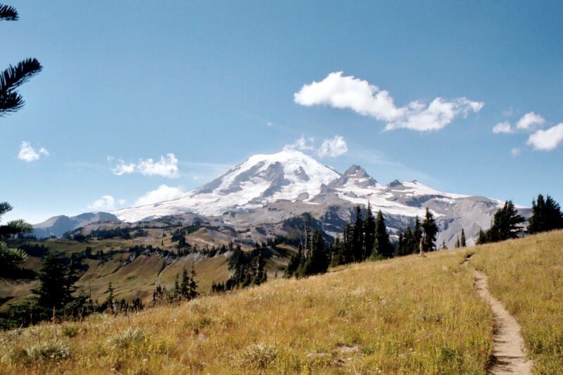
The Wonderland Trail spans 93 miles around Mount Rainier, Washington’s most glaciated peak. This challenging loop requires 7-12 days to complete.
Hikers encounter 27,000 feet of elevation gain and loss through diverse terrain. The trail passes through old-growth forests, subalpine meadows, and alpine ridges.
Mount Rainier’s glaciers provide ever-changing views from all angles. Cascading waterfalls and glacial rivers punctuate the landscape throughout the journey.
Wildlife includes marmots, mountain goats, and black bears. The trail offers access to some of the Pacific Northwest’s most pristine wilderness areas.
Permits are required for backpacking and are highly competitive. Advanced planning is essential due to limited availability and challenging logistics.
The combination of technical difficulty and world-class scenery makes this one of America’s premier long-distance hiking experiences.
11. Acadia National Park Precipice Trail, Maine
The Precipice Trail stands as one of the most challenging hikes in Acadia National Park. This 2.1 to 2.5-mile trail ascends the dramatic cliffs of Champlain Mountain.
Hikers navigate steep rock faces using iron rungs, ladders, and narrow ledges. The trail requires a good head for heights due to significant exposure along the route.
The path begins with a traverse across rugged talus slopes. Wooden bridges and iron handrails assist climbers through the most technical sections.
Located on Park Loop Road, the trailhead sits approximately ten minutes from Bar Harbor. The trail offers commanding views of Frenchman Bay and the surrounding coastline.
This hike demands proper preparation and is not suitable for those uncomfortable with heights. The combination of technical climbing elements and stunning vistas makes it a memorable experience for adventurous hikers.
12. Rocky Mountain National Park Sky Pond, Colorado
Sky Pond offers one of Colorado’s most rewarding alpine adventures. The trail begins at Glacier Gorge Trailhead and spans approximately 10 miles roundtrip.
Hikers encounter multiple waterfalls, glacial lakes, and stunning mountain vistas. The route passes through Loch Vale and Lake of Glass before reaching Sky Pond at 10,800 feet elevation.
The trail’s unique feature requires scrambling up a waterfall near the end. This rock climbing section adds excitement but demands caution and proper footwear.
Taylor Glacier and jagged Rocky Mountain peaks provide dramatic backdrops. The alpine setting showcases some of the park’s most pristine wilderness.
Visitors need reservations for the Bear Lake Corridor due to popularity. The shuttle system may be required during peak seasons.
This challenging hike rewards experienced hikers with diverse terrain and exceptional mountain scenery.
13. Blue Ridge Parkway Peaks of Otter, Virginia
The Peaks of Otter area sits at milepost 86 along Virginia’s Blue Ridge Parkway. This destination offers multiple hiking trails within the Jefferson National Forest.
Sharp Top Trail stands as the most popular option. The 3-mile round trip hike leads to Sharp Top Mountain’s summit. This trail starts at the Nature Center and provides a strenuous climb.
The area features trails for different skill levels. Easy paved paths offer gentle walks near the visitor center. More challenging routes lead to mountain summits with panoramic views.
Peaks of Otter has attracted visitors for over 8,000 years. The location includes a visitor center, lodge, and campground facilities. Three primary mountain peaks form this scenic area.
Hikers can access waterfalls and 360-degree mountain views. The trails range from short nature walks to full-day adventures through Virginia’s Blue Ridge Mountains.
14. Smoky Mountains Alum Cave Trail, Tennessee
The Alum Cave Trail stands as one of the most celebrated hiking routes in Great Smoky Mountains National Park. This Tennessee trail offers hikers spectacular views and unique geological features along its challenging path.
The trail spans approximately 4.6 miles roundtrip to reach the famous Alum Cave Bluffs. Hikers encounter diverse landmarks including Arch Rock, a natural stone formation that creates a tunnel-like passage.
At 2.3 miles from the trailhead, visitors reach the Alum Cave Bluffs themselves. The trail continues climbing past Inspiration Point, where panoramic mountain views reward the effort.
Located along Newfound Gap Road between Gatlinburg and Cherokee, the trailhead provides easy access. However, parking fills quickly due to the trail’s popularity among visitors.
The route features old-growth forests, mountain streams, and diverse wildlife. Past Arch Rock, the trail becomes considerably steeper, challenging hikers with its demanding ascent through the Smoky Mountains terrain.
15. Shenandoah National Park Old Rag Mountain, Virginia
Old Rag Mountain stands as the most popular hiking destination in Shenandoah National Park. This 9.4-mile loop trail reaches 3,284 feet elevation near Sperryville in Madison County.
The trail features challenging rock scrambles and technical climbing sections. Hikers navigate exposed rocky terrain that sets Old Rag apart from other Blue Ridge Mountains peaks.
The summit rewards visitors with 360-degree panoramic views. This challenging route attracts experienced hikers seeking adventure and scenic vistas.
Advanced reservations are required from March 1 through November 30. Hikers must obtain day-use tickets in addition to park entrance passes during peak season.
Dogs are not permitted on this trail. The route typically takes 6-8 hours to complete depending on hiking experience and crowd levels.
16. Mount Katahdin Knife Edge, Maine
Mount Katahdin’s Knife Edge Trail stands as one of Maine’s most challenging and renowned hiking experiences. This narrow ridge connects Pamola Peak to Baxter Peak, stretching 1.1 miles across exposed granite.
The complete hike covers approximately 8 miles with 4,000 feet of elevation gain. Hikers reach Maine’s highest summit at 5,267 feet above sea level.
The trail requires scrambling along a narrow ridge with significant exposure on both sides. Weather conditions can change rapidly, making preparation essential for safety.
Multiple access routes lead to the Knife Edge, including the Helon Taylor Trail and Hunt Trail. The northern terminus of the Appalachian Trail sits atop Baxter Peak.
Located in Baxter State Park, the trail attracts experienced hikers seeking technical terrain. The exposed granite ridge offers panoramic views across Maine’s wilderness landscape.
17. Joshua Tree Wall Street Mill Trail, California
The Wall Street Mill Trail offers hikers a fascinating glimpse into California’s gold mining history. This 1.8-mile out-and-back trail winds through Joshua Tree National Park near Twentynine Palms.
Hikers encounter well-preserved ruins of the historic Wall Street Mill, where Bill Keys processed gold ore during the 1930s. The trail features rusted vehicles, abandoned mining equipment, and remnants of the Wonderland Ranch scattered across the desert landscape.
The route takes about 39 minutes to complete on mostly flat terrain. Giant boulders and rocky outcroppings provide scenic backdrops throughout the hike.
October through May offers the best hiking conditions. The trail attracts fewer visitors than nearby Barker Dam, making it ideal for those seeking a quieter experience.
Dogs are not permitted on this trail. The area requires a Joshua Tree National Park entrance fee.
18. Olympic National Park Hoh Rain Forest, Washington
The Hoh Rain Forest represents one of the finest examples of temperate rainforest in the United States. This UNESCO World Heritage Site receives approximately 140 inches of rain annually, creating a unique ecosystem of moss-covered trees and towering old-growth forests.
Located on the west side of Olympic National Park, the area sits about two hours from Port Angeles and under an hour from Forks. Visitors can access the rainforest via an 18-mile drive from Highway 101 to the visitor center.
The most popular trails include the Hall of Mosses and Spruce Nature Trail, both offering easy nature loops through the ancient forest. The longer Hoh River Trail provides deeper wilderness exploration along the milky-blue river.
This pristine environment showcases diverse wildlife and primeval ferns beneath towering canopies. The trails rank among the busiest in Olympic National Park, attracting half a million visitors annually to experience this exceptional temperate rainforest ecosystem.
19. Lost Coast Trail, California
The Lost Coast Trail stretches 25 miles along California’s most pristine undeveloped coastline. This rugged backpacking route runs through the King Range Wilderness in Humboldt County.
The northern section starts at Mattole Beach Trailhead and ends at Black Sands Beach. Hikers traverse remote beaches, rocky headlands, and coastal wilderness areas.
The trail requires careful tide planning and permits. Several creek crossings and beach sections become impassable during high tide.
Late May through September offers the best hiking conditions. Winter months bring heavy rainfall and challenging weather patterns.
Backpackers need proper gear for coastal camping and variable conditions. The route typically takes 3-4 days to complete.
This trail represents California’s longest stretch of undeveloped coastline. The challenging terrain and remote location make it suitable for experienced hikers seeking pristine wilderness.
20. Superior Hiking Trail, Minnesota
The Superior Hiking Trail stretches 310 miles along Lake Superior’s North Shore from Jay Cooke State Park to the Canadian border. This trail follows rocky ridgelines above the massive lake through eight state parks.
The trail offers options for day hiking, backpacking, and thru-hiking. Hikers can choose from various difficulty levels across different sections. The complete thru-hiking portion spans 269 miles.
Over 300 miles of trail wind through forests along Lake Superior’s coast. The path provides stunning lake views and passes through both public and private lands.
The Superior Hiking Trail Association maintains this nonprofit trail from their Two Harbors base. Multiple trailheads with parking lots allow hikers to access different sections easily.
The trail features designated campsites and connects to nearby lodges for overnight stays.
21. Death Valley Golden Canyon, California
The Golden Canyon Trail offers hikers a chance to explore one of Death Valley’s most distinctive landscapes. This popular trail winds through sandstone canyons and golden mudstone hills that create the park’s signature desert scenery.
The basic Golden Canyon hike covers 0.8 miles out-and-back and takes about 21 minutes to complete. Hikers can extend their adventure by combining it with the Gower Gulch Loop and Badlands Loop for a more comprehensive experience.
The trail provides multiple route options ranging from easy walks to strenuous hikes. A 1.4-mile detour leads to Zabriskie Point, which offers views of Manly Beacon, a prominent pointed rock formation.
The best hiking season runs from October through April when temperatures are more manageable. Dogs are not permitted on this trail, and hikers should expect to encounter other visitors due to the area’s popularity.
22. Badlands Loop Trail, South Dakota
The Badlands Loop Trail follows Highway 240 through Badlands National Park, offering hikers access to multiple trailheads and stunning geological formations. This scenic route serves as the backbone for exploring the park’s diverse hiking opportunities.
Most developed trails in the park begin from parking areas along this loop road. The accessibility makes it easy for visitors to experience the park’s unique landscape without extensive planning.
Badlands National Park features an Open Hike Policy, allowing hikers to explore off-trail areas beyond the designated paths. This flexibility lets adventurers discover hidden formations and create their own routes through the rugged terrain.
The loop provides access to trails ranging from easy boardwalks to challenging wilderness hikes. Popular starting points include the Cedar Pass area, where most visitors begin their Badlands hiking experience.
The trail system accommodates all skill levels, from families seeking short walks to experienced hikers pursuing longer adventures.
23. Haleakala Summit Trail, Hawaii
Haleakala National Park offers over 30 miles of hiking trails across its summit area. The trails range from easy 10-minute walks to challenging multi-day backpacking adventures.
The Sliding Sands Trail stands out as the main summit route. This trail descends into Haleakala’s massive crater, revealing otherworldly volcanic landscapes at 10,000 feet elevation.
Leleiwi Overlook Trail provides an accessible option at just 0.3 miles roundtrip. Hikers experience panoramic crater views and moonlike terrain from 8,800 feet elevation.
The summit district trails showcase unique volcanic formations and rare native plants. Weather conditions can change rapidly at high altitude, requiring proper preparation and layered clothing.
These trails offer distinct perspectives of one of the world’s largest dormant volcanic craters. The landscape differs dramatically from typical Hawaiian tropical environments.
24. Green Mountain Trail, Vermont
The Green Mountain Trail in Vermont spans 9.0 miles as an out-and-back route near Danby. This challenging trail requires approximately 4 hours and 30 minutes to complete.
Hikers encounter rugged terrain through Vermont’s Green Mountains. The trail offers excellent opportunities for backpacking, camping, and day hiking.
The route remains open year-round and attracts relatively few visitors. This provides a more secluded hiking experience compared to busier Vermont trails.
The trail showcases Vermont’s natural beauty across all seasons. Spring, summer, and autumn bring distinct foliage changes, while winter offers snow-covered mountain landscapes.
Located within the Green Mountain National Forest, the trail connects to the broader network of Vermont hiking opportunities. The area features portions of both the Long Trail and Appalachian Trail systems.
The challenging difficulty rating makes this trail suitable for experienced hikers seeking a substantial workout.
25. Grandfather Mountain Profile Trail, North Carolina
The Profile Trail at Grandfather Mountain State Park offers one of North Carolina’s most challenging hiking experiences. This strenuous 7.2-mile round-trip trail begins at 3,800 feet elevation and climbs 1,775 feet to reach Calloway Gap.
The trailhead is located on NC Highway 105 near Sugar Mountain in Banner Elk. Hikers can access the trail for free, making it an alternative to the paid attraction areas of Grandfather Mountain.
The trail passes through seven different natural communities as it winds up the mountain’s western slope. Hikers encounter challenging terrain with steep climbs throughout the ascent.
From Calloway Gap, adventurous hikers can continue to Calloway Peak, the highest point of Grandfather Mountain at 5,946 feet. The trail provides spectacular views of the Blue Ridge Mountains and surrounding wilderness areas.
26. Canyonlands Needles District, Utah
The Needles District showcases some of Utah’s most distinctive desert landscapes. Named for its colorful spires of Cedar Mesa Sandstone, this southeastern section of Canyonlands National Park offers exceptional hiking opportunities.
The Slickrock Foot Trail provides an ideal introduction to the area. This easy loop trail stays on elevated terrain and delivers panoramic views of the surrounding rock formations.
Chesler Park Loop Trail ranks among the district’s premier hikes. The trail winds through a natural amphitheater surrounded by towering sandstone pinnacles and offers access to remote desert terrain.
The Joint Trail takes hikers through narrow slot canyons carved between massive rock walls. This unique route demonstrates the area’s geological complexity and provides a different perspective on the landscape.
Tower Ruin and Confluence Overlook trails lead to significant archaeological sites and scenic viewpoints. These longer day hikes reward visitors with expansive vistas of the Colorado River system.
27. Mammoth Cave National Park, Kentucky
Mammoth Cave National Park features nearly 80 miles of hiking trails that showcase Kentucky’s distinctive karst landscape. The park offers diverse terrain including limestone ridges, forested hills, and underground springs.
The Green River Bluffs Trail provides scenic overlooks of the Green River valley. River Styx Spring Trail leads hikers to natural springs that disappear underground into the cave system below.
Cedar Sink Trail offers views of a large sinkhole formation typical of the region’s geology. The Echo River Spring Trail connects visitors to another underground water source.
Sunset Point delivers panoramic views across the rolling Kentucky countryside. The Maple Springs backcountry area provides more challenging terrain for experienced hikers.
Trail difficulty ranges from easy nature walks to strenuous backcountry routes. The park’s trail system allows exploration of the surface landscape above one of the world’s longest known cave systems.
28. Mesa Verde Petroglyph Point Trail, Colorado
The Petroglyph Point Trail winds through Mesa Verde National Park as a 2.4-mile loop hike. This moderately challenging route takes hikers through rugged canyon terrain to view ancient Puebloan petroglyphs and ruins.
The trail begins near the Chapin Mesa Museum and follows historic pathways once used by Ancestral Pueblo people. Hikers descend into forested Spruce Canyon before climbing back along rocky terrain to the canyon rim.
The main attraction sits 1.4 miles from the trailhead at the park’s largest petroglyph panel. These ancient rock art displays offer glimpses into the lives of the area’s early inhabitants.
Trail users enjoy panoramic views of Spruce and Navajo Canyons throughout the hike. The route provides the only opportunity to experience Mesa Verde’s archaeological features in a backcountry setting without guided tours.
Dogs are not permitted on this trail, and it typically closes during winter months.
29. Zion The Narrows, Utah
The Narrows offers one of America’s most unique hiking experiences through a slot canyon in Zion National Park. Hikers walk directly in the Virgin River between towering canyon walls that reach over 1,000 feet high.
The canyon narrows to just 20-30 feet wide in some sections. This creates an intimate experience as hikers navigate through the flowing water surrounded by massive red rock walls.
Two route options exist for experiencing The Narrows. The bottom-up approach starts from the Riverside Walk and requires no permits for day hiking. The top-down route is a full-day adventure that needs advance permits.
Water levels and weather conditions significantly impact the hike’s difficulty and safety. Park entrance fees apply, with vehicles paying $35 or using the America the Beautiful Pass for access.
The combination of river hiking and narrow canyon walls makes this trail unlike any other in the United States.
30. Muir Woods Dipsea Trail, California
The Dipsea Trail stands as one of California’s most historic hiking routes, connecting Mill Valley to Stinson Beach through Muir Woods National Monument. This 7.5-mile trail offers hikers towering coastal redwoods and scenic Pacific Ocean views.
The trail begins with 688 stairs from Mill Valley before crossing into Muir Woods. Hikers traverse beneath ancient redwood groves that showcase some of the world’s tallest trees.
The route continues through Mount Tamalpais State Park, climbing steep sections through Douglas firs and rooty singletrack terrain. The challenging ascent known as Cardiac Hill tests endurance with its rapid elevation gain.
The Dipsea Trail hosts America’s oldest trail race, second only to the Boston Marathon in racing history. This prestigious event has drawn runners to the challenging course for over a century.
The trail concludes at Stinson Beach, where hikers can enjoy coastal views and ocean access after completing this demanding but rewarding Northern California adventure.
How to Prepare for America’s Best Hiking Trails
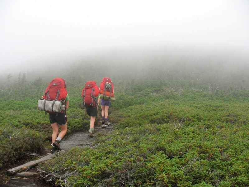
Proper preparation determines the difference between an enjoyable adventure and a dangerous situation on America’s most challenging trails. Success depends on selecting appropriate gear, understanding safety protocols, and accurately assessing trail difficulty levels.
Essential Gear and Packing Tips
Navigation and Communication
Hikers should carry a detailed topographic map, compass, and GPS device for every trail. Cell phone coverage remains unreliable in remote areas, making satellite communicators essential for multi-day trips.
Clothing and Footwear
Layering systems work best for varying weather conditions. Base layers should wick moisture, insulating layers provide warmth, and outer shells protect against wind and rain. Proper hiking boots with ankle support prevent injuries on rocky terrain.
Water and Nutrition
Hikers need one liter of water per two hours of moderate activity. Water purification tablets or filters become necessary when refilling from natural sources. High-energy snacks like nuts, dried fruit, and energy bars sustain energy levels throughout long hikes.
Emergency Supplies
First aid kits must include bandages, antiseptic wipes, pain relievers, and personal medications. Emergency shelters, headlamps with extra batteries, and multi-tools handle unexpected situations. Sunscreen and insect repellent protect against environmental hazards.
Safety Considerations and Trail Etiquette
Pre-Trip Planning
Hikers should inform someone about their planned route, expected return time, and emergency contacts. Weather forecasts and trail condition reports help identify potential hazards before departure.
Wildlife Awareness
Bear canisters store food properly in bear country. Hikers should maintain distance from all wildlife and never feed animals. Making noise while hiking alerts animals to human presence and reduces surprise encounters.
Trail Courtesy
Uphill hikers have right-of-way on narrow trails. Hikers should yield to horses and step aside for mountain bikers when safe. Leave No Trace principles require packing out all trash and staying on designated trails.
Emergency Protocols
Hikers should turn back if weather conditions deteriorate or physical capabilities become compromised. Carrying emergency whistles helps signal for help when needed. Understanding basic first aid procedures proves valuable in remote locations.
Understanding Trail Difficulty Ratings
Standard Rating System
Most trails use a three-tier system: easy, moderate, and difficult. Easy trails feature minimal elevation gain and well-maintained paths. Moderate trails include some steep sections and may require basic scrambling skills.
Elevation and Distance Factors
Trails gaining more than 1,000 feet per mile qualify as strenuous. Distance alone doesn’t determine difficulty, as terrain and weather conditions significantly impact hiking challenges. Alpine environments above treeline present additional risks regardless of distance.
Technical Skills Required
Class 1 trails require only basic walking skills. Class 2 trails involve simple scrambling over rocks. Class 3 routes demand handholds and basic climbing techniques with potential fall consequences.
Personal Fitness Assessment
Hikers should honestly evaluate their cardiovascular fitness and experience level. Starting with shorter, easier trails builds necessary skills and conditioning. Previous hiking experience in similar terrain provides the best preparation for challenging routes.
Tips for Maximizing Your U.S. Hiking Experience
Planning your timing, following environmental ethics, and connecting with local communities can transform an ordinary hike into an exceptional adventure. These strategies help hikers make the most of America’s diverse trail systems while ensuring sustainable outdoor recreation.
Best Times to Visit Top U.S. Trails
Spring (March-May) offers ideal conditions for desert trails in Arizona and Utah before summer heat arrives. Temperatures in places like Joshua Tree and Zion remain comfortable for day hikes.
Summer (June-August) provides the best window for high-altitude trails in Colorado, Montana, and Washington. Snow typically clears from mountain passes by mid-June, opening access to alpine lakes and summit routes.
Fall (September-November) delivers spectacular foliage along East Coast trails like the Appalachian Trail sections in Virginia and North Carolina. Cooler temperatures and fewer crowds make this prime hiking season.
Winter (December-February) suits lower-elevation trails in California, Florida, and the Southwest. Many desert and coastal trails become more pleasant as summer heat subsides.
Weather patterns vary significantly by region and elevation. Hikers should check local conditions and seasonal closures before traveling. Mountain weather can change rapidly regardless of season.
Leave No Trace Principles
Plan ahead and prepare by researching regulations, obtaining permits, and checking weather forecasts. Many popular trails require advance reservations, especially during peak seasons.
Travel and camp on durable surfaces like established trails and designated campsites. Avoid creating new paths or camping in fragile areas like meadows or near water sources.
Dispose of waste properly by packing out all trash, including food scraps and toilet paper. Human waste should be buried 6-8 inches deep and 200 feet from water sources.
Leave what you find by not taking rocks, plants, or artifacts. These items serve important ecological functions and contribute to other visitors’ experiences.
Minimize campfire impacts by using established fire rings where permitted. In many areas, portable stoves provide safer and more efficient cooking options.
Respect wildlife by observing animals from distance and storing food properly. Never feed wild animals as this disrupts their natural behaviors.
Be considerate of other visitors by keeping noise levels down and yielding trail right-of-way appropriately.
Connecting with Local Hiking Communities
Join local hiking clubs through organizations like the Sierra Club, Appalachian Mountain Club, or regional outdoor groups. These organizations offer guided hikes, trail maintenance opportunities, and valuable local knowledge.
Use hiking apps and websites like AllTrails, Hiking Project, and regional trail sites to read recent trip reports and connect with other hikers. These platforms provide current trail conditions and safety updates.
Visit outdoor gear shops in trail towns and gateway communities. Staff members often have extensive local knowledge and can recommend lesser-known trails that match specific skill levels.
Participate in trail maintenance through volunteer programs with organizations like the American Hiking Society or local land management agencies. These activities provide opportunities to meet experienced hikers while contributing to trail preservation.
Attend hiking meetups organized through social media groups or community boards. Many cities have active hiking communities that welcome newcomers and organize regular outings.
Connect with park rangers and visitor centers for up-to-date information about trail conditions, wildlife activity, and seasonal highlights. Rangers often provide insights not available through online resources.


